

Effective, resilient and strategic protected area networks are essential to protect biodiversity and human welfare, especially in vulnerable biodiversity hotspots. This is the case in the Brazilian Cerrado, the richest tropical savanna, and a deforestation front worldwide. Worryingly, the rate of habitat conversion in Cerrado greatly reduces opportunities to conserve its biodiversity. Herein, using the most comprehensive database on the distribution of Cerrado endemic terrestrial vertebrates, we mapped conservation priority areas and evaluated how and to what extent habitat loss and fragmentation reduce conservation opportunities. Priority areas are scattered throughout the Cerrado. Larger priority areas are concentrated in the northern portion of the region. Southern priority areas are small, scattered, and isolated. During the last 35 years, opportunities to conserve large contiguous areas have significantly decreased, hampering the representation of key endemic species. However, as most endemic vertebrates are small ranged, modest but well located increments in total protected area will result in significant overall improvements in the PA system. Protecting the largest priority areas identified here is urgent and mandatory, while using habitat restoration as a key activity to promote connectivity among smaller priority areas, especially in the southern portion of this hotspot.
Creating and managing strategic protected areas (PAs) is fundamental for biodiversity conservation. They are essential to reaching nature-based solutions for adaptation to global changes (Maxwell et al., 2020), maintaining wildlife populations (Geldmann et al., 2013), and ensuring long-term maintenance of nature’s contributions to people (Díaz et al., 2018). Worryingly, despite the sustained increase in numbers of PAs globally (Maxwell et al., 2020), historically PA allocation has not met scientific criteria, being influenced by economic activities and opportunism (Margules and Pressey, 2000). This is particularly true in economically productive ecoregions (Prieto-Torres et al., 2022) such as the Cerrado hotspot (Strassburg et al., 2017; Vieira et al., 2019). In this context, science has developed systematic conservation planning protocols to achieve resilient and effective PAs, based on objective criteria and relevant information (Margules and Pressey, 2000; Di Minin et al., 2014).
Habitat loss and fragmentation are the main causes of species extinctions and declines, hampering population viability of most threatened species (IPBES, 2019; Grande et al., 2020). Conservation opportunities for efficient PAs exponentially decrease as habitat fragmentation advances (Nori et al., 2013). The protection of contiguous patches of natural ecosystems is necessary for the conservation of most key and threatened species, ecological processes, and nature’s contributions to people (Díaz et al., 2018). Sadly, current rates of conversion of the few remaining natural habitats in deforestation hotspots, such as the Brazilian Cerrado, make this unlikely.
The Brazilian Cerrado is the richest savanna in the world, with high levels of endemism (Strassburg et al., 2017). However, this biodiversity hotspot has recently suffered rampant natural habitat loss due to a combination of low legal protection and increased demand for commodities (Pacheco et al., 2021). Additionally, the Cerrado is one of the eight deforestation frontiers undergoing high rates of recent deforestation, with conversion now concentrated in the northern portion of the region, where natural habitats persist as large contiguous areas (Strassburg et al., 2017). Given the context, efficient policy-making toward their conservation is imperative.
Herein, using the most comprehensive revised point-locality database on endemic terrestrial vertebrates of the ecoregion to date, we aimed (i) to determine priority areas for the conservation of Cerrado endemic terrestrial vertebrates; (ii) to determine the increase of habitat fragmentation of priority areas as the agricultural frontier advances; and (iii) to estimate the loss of conservation opportunities over time under current deforestation rates.
Material and MethodsThe Cerrado is the second largest South American phytogeographical domain, dominated by upland savannas and grasslands (Ab’Sáber, 1998). Herein, we adopted the limits of the Cerrado ecoregion as proposed by Dinerstein et al. (2017).
We compiled the most comprehensive revised point-locality database on Cerrado endemic terrestrial vertebrates to date, comprising 13,790 unique records of 337 species, including 124 amphibian anurans, 66 lizards, 63 snakes, 45 birds, and 39 mammals. These records are based on planned field surveys and revision of vouchered specimens in scientific collections, complemented by revised literature data.
From verified point-locality records we created normalized heatmaps representing species distributions. Heatmaps are a simple extrapolation of species records, highlighting regions with a high density of records and giving less weight to pixels towards the edge of the buffered heat core. Compared to other commonly used methods based on correlative extrapolations, and considering the completeness of our database, heatmaps based only on point records minimize potential commission errors as a consequence of spurious projections. Finally, heatmaps avoid overlooking potentially important areas around species records (e.g. decreasing the effect of omission errors). We created heatmaps using the Kernel Density Estimation tool, in QGIS 3.24 (QGIS Development Team, 2022), with a radius of 0.5º around points, and a resolution of ∼20 km2 (0.041667º). We normalized the estimated heat values by dividing the resulting raster file by its maximum value, therefore obtaining a continuous output from zero to one for all species.
We used Zonation 4.0 (Moilanen et al., 2014) to locate priority areas for the 337 studied species. The software implements hierarchical prioritization of areas based on the distribution of biodiversity features, considering predefined user input weights for each feature. We ran prioritizations under the Core Area Zonation (CAZ) rule. CAZ rule identifies high-priority areas as those presenting a high occurrence level of a single rare or highly weighted feature (Di Minin et al., 2014). This removal rule was selected given that the input species are endemic to the Cerrado, and many are restricted to small portions of the region. To select optimal areas for expanding the PA network, we included existing PAs as a hierarchical mask (Di Minin et al., 2014). We included all PA categories, with strict and non-strict conservation goals, such as National and State Parks, Ecological Stations, and private areas such as “APAs” and “RPPNs”, in our analysis.
To emphasize the importance of small-ranged, threatened (VU, EN, CR) or poorly known taxa (DD), we generated a simple index including both categories. Our weighted index is the result of a multiplication of values from 1 to 3 (“widespread” = 1, “partial” = 2, and “restricted” = 3, see Nogueira et al., 2019) for range size, and values from 1 to 5 according to IUCN extinction risk categories (LC = 1, NT = 2, VU and DD = 3, EN = 4 and CR = 5; IUCN, 2022). To avoid overestimating the importance of species not assessed by IUCN, and those classified as DD within less than ten years after description, these were weighted with the value “2” in the extinction risk ‘part’ of the index. This results in a higher weight than that of species in “Least Concern” while not surpassing the weight of those still classified as DD ten years after description (e.g. higher weight = “3”, see above; Morais et al., 2013).
To penalize pixels covered by anthropic land uses, we included reclassified binary land-use maps (obtained from MapBiomas, 2022; reclassification details in Appendix S1) as a negative variable weighted as the sum of all positive variable weights. To assess how priority areas shifted according to land use and land cover (LULC) changes in the last decades, we repeated the analyses using land-use scenarios from 1985 to 2020 (MapBiomas, 2022) in five years intervals, considering also a pristine Cerrado scenario (e.g. without LULC changes).
According to the Aichi Biodiversity Targets (CBD, 2010), PA networks should represent at least 17% of the world's landmass (see Target 11; CBD, 2010). In addition to the 17% target, we also mapped a recently proposed target of 30% (post-2020 global biodiversity framework, Woodley et al., 2019). Finally, to analyze the effect of LULC changes and resulting fragmentation on priority areas over time, we grouped priority areas (i.e. connected pixels) depending on their area (for additional details see the extended methods, Appendix S2).
ResultsOf the 337 analyzed species, 262 (77.4%) have been assessed by IUCN. Of those, 39 (11.5%) are considered threatened, including 17 Vulnerable, 15 Endangered, and seven Critically Endangered (Appendix S3). Sixty-one species are considered Data Deficient, of which 57 (93.4%) were described more than 10 years ago. Amongst the 75 species not assessed by IUCN, 77% (N = 58) are restricted-range species, and the remaining 23% (N = 17) are partially-distributed species.
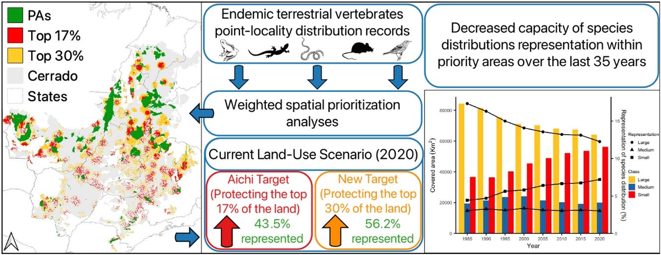
The current PA network covers 10.25% of the Cerrado and putatively protects on average 21.47% of the distributions of endemic terrestrial vertebrates. Four species are completely absent from the system (Appendix S4). According to the prioritization, using the most recent land-use map (2020 scenario), protecting an additional 6.75% of the region (∼135,000 km2, i.e. 17% of the Cerrado) would represent at least 10% of each distribution and increase the average representation to 43.5%. In comparison, the protection of 30% of top priority areas would increase this figure by an additional 12.7%, representing at least 16.6% of each distribution and an average of 56.2% of mapped ranges. Detailed information on species representation in the current PA network and in each conservation target can be found in the supplementary material (Appendix S4).
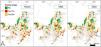
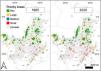
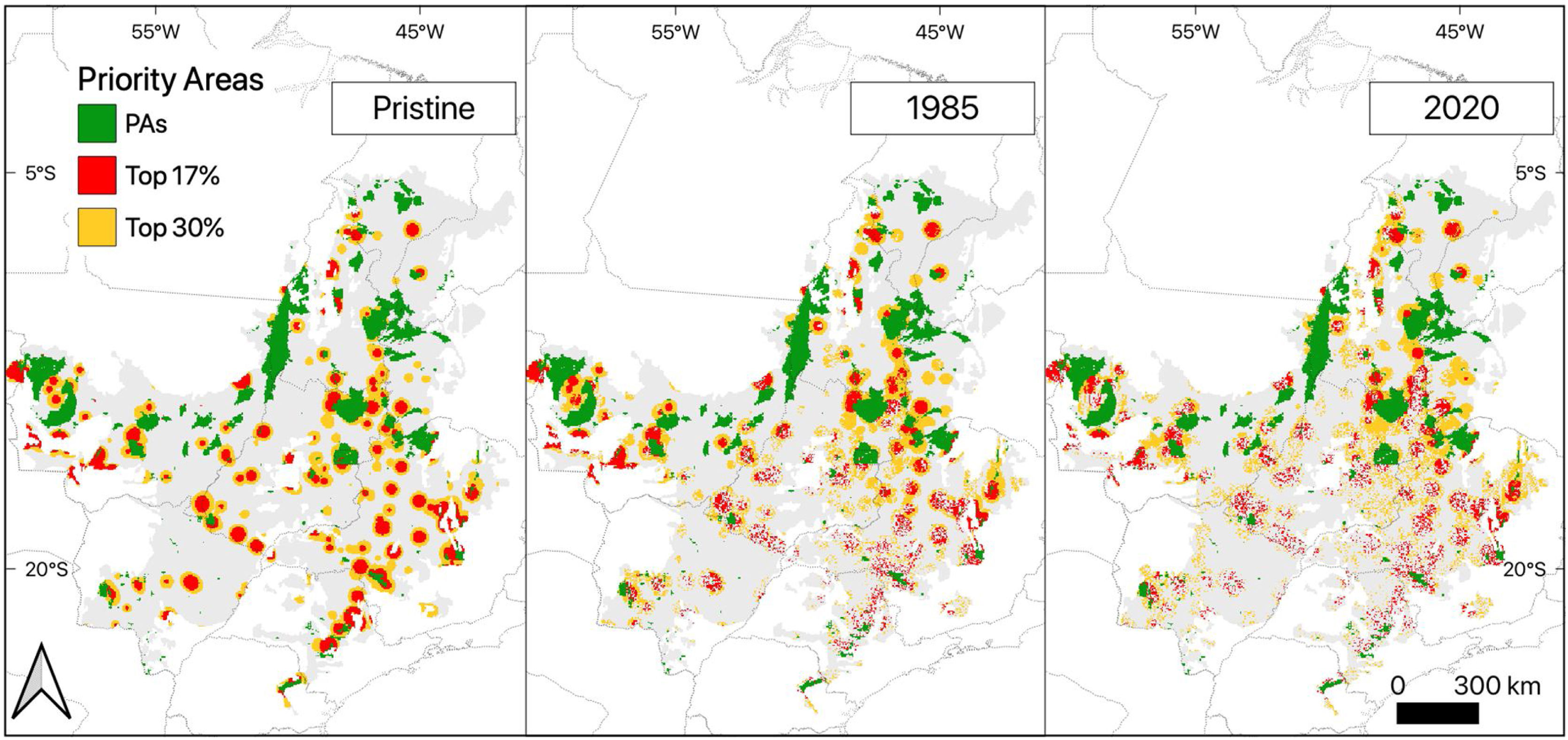
Despite the similar overall location of the top 17% and 30% priority areas, in the pristine scenario the priority areas were represented only by patches of continuous land, while in the 1985 and 2020 scenarios top priority areas also comprise some sparsely distributed discontinuous areas (Fig. 1). While in the pristine scenario continuous priority areas were spread across the Cerrado, in the 1985 and 2020 scenarios they were concentrated in the northern portion of the region, while largely segregated priority areas were mostly spread over the southern portion (Fig. 1). As for the patch size analysis of the top 17% priority areas, opportunities to create, expand and connect PAs in large continuous extensions of natural habitats were concentrated in Mato Grosso, Minas Gerais, Goiás and Tocantins states (Fig. 2; Box 1). On the other hand, patches of medium to small priority areas are scattered throughout the southern portion of the region (Fig. 2).
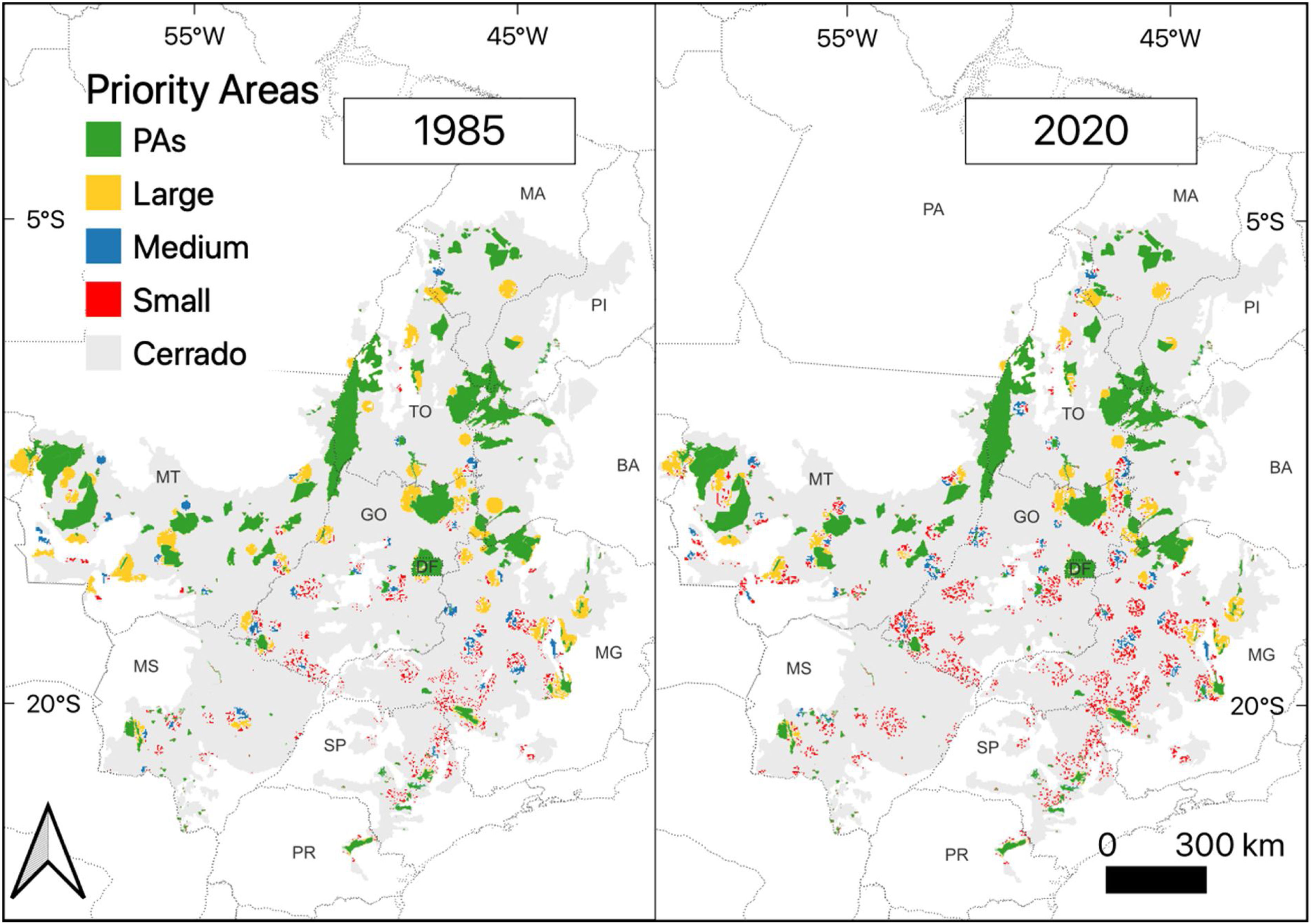
Top 17% of the Cerrado ecoregion for the conservation of endemic terrestrial vertebrate species, classified into three categories according to the territorial extension achieved upon the creation of protected areas. Thresholds considered were: over 1000 km2 for "Large" areas, and under 250 km2 for "Small" ones. Areas between 250 km2 and 1000 km2 were considered as "Medium". State initials stand for: BA: Bahia; DF: Distrito Federal; GO: Goiás; MA: Maranhão; MG: Minas Gerais; MS: Mato Grosso do Sul; MT: Mato Grosso; PA: Pará; PI: Piauí; PR: Paraná; SP: São Paulo and TO: Tocantíns.
In Mato Grosso, priorities are on a northward expansion of the Chapada dos Guimarães National Park, preferably aiming for a connection with the APA Cabeceiras do Rio Cuiabá. Our results also highlight the need to expand the Serra das Araras Ecological Station, and to implement new protected areas on the border and across the eastern portion of Rondônia state, as well as connecting large extensions of indigenous lands in the westernmost limits of the Cerrado (Fig. 2). In Minas Gerais state, the focus should be given to the expansion and connection of the Sempre Vivas National Park with Rio Preto and Biribiri State Parks, as well as for the connection between the Grão Mogol and Botumirim State Parks with the Acauã Ecological Station. Our results also highlight an opportunity for a great expansion around Serra do Cabral State Park, a moderate expansion around Serra da Canastra National Park, and the opportunity to create a large protected area in northwestern Minas Gerais, near the small Sagarana State Park (Fig. 2). In the northeastern portion of the Goiás state, at the border with Bahia, there is an opportunity to expand and connect the protected areas located at the Serra Geral plateau. As for northern Goiás and southern Tocantins, large extensions of natural habitat can be protected by the expansion of the Chapada dos Veadeiros National Park, and the APA Minaçu, aiming for connections with APA Pouso Alto in the east, and with APA Lago de São Salvador do Tocantins, Paranã and Palmeirópolis in the north (Fig. 2). Finally, for the northern portion of the Tocantins state our results highlight the opportunity to expand the APA Serra do Lageado; to expand the Árvores Fossilizadas Natural Monument aiding in the connection with the Chapada das Mesas National Park in eastern Maranhão state, and for the creation of a new protected area on the upper Tocantins river valley at the municipality of Guaraí. Notwithstanding, a large priority area is located in the municipality of Loreto in eastern Maranhão state, and an eastward expansion of Uruçuí-Una Ecological Station in Piauí state is also amongst the top 17% large priority areas (Fig. 2).
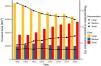
The analyses of priority areas considering temporal series of LULC changes revealed a clear negative effect of postponing conservation action in the Cerrado. Opportunities to represent endemic terrestrial vertebrate distributions decreased with the conversion of natural habitats into anthropic uses (Table 1, Fig. 3). The average species distribution representation in large areas decreased as we compare the prioritization outcomes of recent land-use changes (from 17.3% to 12.2% in the 1985 and 2020 scenarios respectively, a difference of ∼−5.1%). On the contrary, the representation of species distributions in combined small and medium fragmented priority areas increased over time (from 7.4% to 10.2% in the 1985 and 2020 scenarios respectively, a difference of ∼+2.8%; Fig. 3).
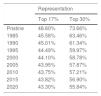
Percentage of endemic terrestrial vertebrate distribution representation in priority areas according to two targets of land protection in different scenarios of past land-use in the Brazilian Cerrado.
| Representation | ||
|---|---|---|
| Top 17% | Top 30% | |
| Pristine | 48.60% | 73.66% |
| 1985 | 45.58% | 63.46% |
| 1990 | 45.01% | 61.34% |
| 1995 | 44.49% | 59.97% |
| 2000 | 44.10% | 58.78% |
| 2005 | 43.95% | 57.87% |
| 2010 | 43.75% | 57.21% |
| 2015 | 43.82% | 56.90% |
| 2020 | 43.30% | 55.84% |
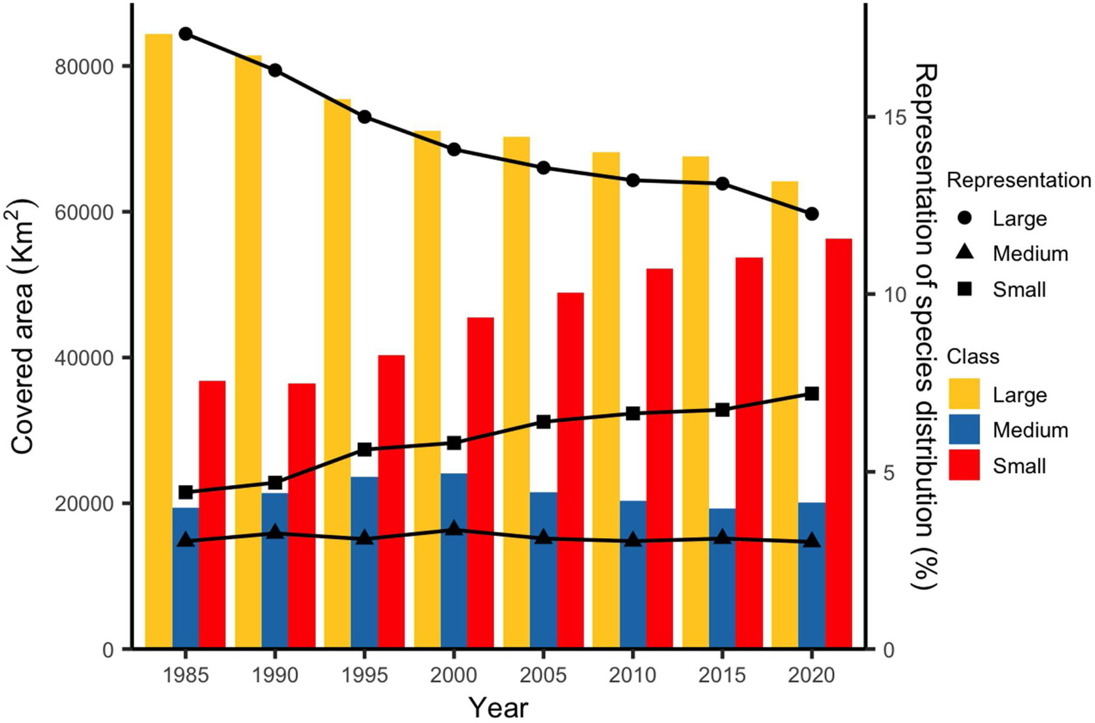
Changes in the total area covered by three different size categories of the top 17% priority areas for the conservation of Cerrado endemic terrestrial vertebrate species throughout time and respective percentage of species distributions within each category. Thresholds considered were: over 1000 km2 for "Large" areas, and under 250 km2 for "Small" ones. Areas between 250 km2 and 1000 km2 were considered as "Medium".
In agreement with previous studies (e.g. Prieto-Torres et al., 2020, 2022), our findings suggest a suboptimal distribution of current Cerrado PAs. Considering that this region was pointed long ago as a biodiversity hotspot (Myers et al., 2000) and is currently a deforestation frontier (Pacheco et al., 2021), strategic land-use planning is a pending issue that should be urgently addressed (Strassburg et al., 2017; Lemes et al., 2020). Otherwise, conservation opportunities will continue diminishing with the increase in habitat loss and fragmentation in these highly diverse savannas (Nori et al., 2013; Resende et al., 2019).
Herein we identified strategic areas to efficiently expand the Cerrado PA network. Most importantly, relatively small increments in the total protected area resulted in a significant increase in species representation. The 17% land protection target was due in 2020 (CBD, 2010) and has not been achieved yet, therefore the protection of the Brazilian Cerrado lags far behind the new ambitious target (30%; Woodley et al., 2019). By comparing priority areas across different periods during the last decades, we pinpointed that habitat loss and fragmentation are the most important factors behind the rapid loss of conservation opportunities in the Cerrado (see also Grande et al., 2020). While opportunities to increase the representation of species distributions did not decrease sharply over time, the top priority areas became smaller and fragmented as time passed. As a consequence, opportunities to represent species distributions in large priority areas (>1000 km2) are decreasing as a result of the conversion of natural habitats into anthropic land use. Noteworthy, the increase in small and medium priority areas does not surpass the decrease of representation in larger ones, suggesting that the protection of large priority areas in the Cerrado should be more urgent than the protection of the smallest areas that have remained after the northward shift in the deforestation frontier (Betts et al., 2017; De Marco et al., 2020).
Habitat connectivity in the Cerrado has decreased sharply during the last decades, mostly due to the loss of connecting fragments. Unfortunately, connectivity is being lost faster than the loss of natural habitats and we are close to a lower threshold of remaining habitats below which connectivity becomes severely compromised (Grande et al., 2020). Considering the habitat requirements of many of the species assessed here, large portions of connected natural environments are important to safeguard the maintenance of ecological processes (Betts et al., 2017; Díaz et al., 2018). The northern portion of the region encompasses the largest continuous priority areas even in the most recent and pessimistic land-use scenario. Worryingly, the Deforestation Front report (Pacheco et al., 2021) highlights the northern portion of the Cerrado as the most impacted worldwide and forecasts a trend of persistent deforestation in the region. This evidence, coupled with our results, suggests a clear trend of further reduction of conservation opportunities if no actions are urgently taken to halt habitat loss in the Cerrado, especially in its northern portion (Nori et al., 2013; Resende et al., 2019). Although the small and isolated priority areas detected here might not be adequate for some of our target species (see De Marco et al., 2020), those located in the southern portion of the Cerrado are the last remaining habitat for many endemic vertebrate species studied herein and must not be overlooked.
Some regions of the northern portion of the Cerrado (e.g. Serra Geral plateau) remained climatically stable during the Quaternary climatic fluctuations (Werneck et al., 2012). This climatic stability conferred a conservation uniqueness in light of global climate change. Moreover, a study using a framework directed to halt vegetation loss combined with predictions of species distributions under climate change scenarios highlights priority areas for plant conservation in northern Cerrado (Monteiro et al., 2020), converging with our proposal, and others (e.g. Brum et al., 2019; Diniz-Filho et al., 2020; Pacheco et al., 2021). For future scenarios, however, the southern portion of the Cerrado is hypothesized to be climatically stable (De Marco et al., 2020; Diniz-Filho et al., 2020). So, the last remnants in the highly impacted southern portions should be preserved and reconnected via restoration activities (Strassburg et al., 2017). There is an opportunity to safeguard enough protection for species while also increasing agricultural production without impacting the remaining natural habitats in the Cerrado (Strassburg et al., 2017). This "greener scenario" and zero deforestation approach points also to the necessity of implementing restoration in critical areas, mostly in the southern portion of the ecoregion. In this sense, following our prioritization scheme and considering both the threat of current deforestation in northern Cerrado and the outstanding presence of discontinuous priority areas in the southern portion of the region (Grande et al., 2020), we propose the urgent implementation of new PAs on the northern Cerrado as the last chance to maintain naturally connected areas. In addition, the focus on restoration approaches should be directed towards the southern priority areas, especially those with the potential to be connected to compose conservation mosaics.
In fact, small and fragmented areas in southern Cerrado may serve as the backbone of larger conservation strategies focused on landscape connectivity and widespread, threatened species. Moreover, as most of our target species are relatively small-ranged and regionalized (Nogueira et al., 2011; Azevedo et al., 2016), given that creating large and continuous PAs is not a possibility, the question of conserving southern Cerrado endemics, is more of a problem of correctly locating PAs. Although small and highly fragmented, the few remaining Cerrado areas in the south are still home to hundreds of endemic vertebrate species studied herein. To lose more habitat in these areas would lead to very high extinction rates in the Cerrado, which would not be compensated by actions in the more connected and extensive northern areas. In agreement with previous biogeographical studies in the Cerrado, detecting complex, regionalized, and significantly co-distributed allopatric biotas (Nogueira et al., 2011; Azevedo et al., 2016), our priority areas span different portions of the Cerrado. Thus, resulting conservation strategies must adapt to each subregional land use context. In this sense, it is imperative to halt deforestation in the entire Cerrado, both in the highly fragmented south and in the current deforestation frontier in the north. Additionally, it would be essential to guarantee the representation of most of the Cerrado vegetational gradient as possible, since not only vascular plants (see Durigan et al., 2003), but all endemic terrestrial vertebrate groups analyzed here (e.g. Nogueira et al., 2011; Valdujo et al., 2012; Carmignotto et al., 2022) include habitat specialists depending on different habitats covering the Cerrado ecoregion, from gallery forest to savannas, woodlands, wetlands, and open grasslands.
The number of Data Deficient species and those not yet assessed by IUCN highlights a major knowledge shortfall that might hamper accurate policy-making in Cerrado. This implies that research investment aimed to fill knowledge gaps on these species could be considered a strategic investment to reach accurate conservation recommendations (Nori et al., 2018, 2020). Noteworthy more than half of the Cerrado endemic terrestrial vertebrate species classified as DD are amphibians (Appendix S3). It has been shown that most DD amphibians are facing a high extinction risk, especially in Brazil (Morais et al., 2013). Efforts to reduce the proportion of DD species on the IUCN redlist should be mandatory as this general "non-threatened" category is often overlooked by both the scientific community and decision-makers, leading to biased conservation recommendations (Nori et al., 2018).
Recent studies focused on the conservation of ecosystem services also highlight that time is critical for conserving the Brazilian Cerrado (Resende et al., 2019). Projections of land-use conversion under a business-as-usual scenario and forecasted extinctions in the next 30 years are clear proof that not only conservation policies should be immediately directed towards the protection of the Brazilian Cerrado, but also the whole cooperation of public and private sectors is necessary to achieve meaningful conservation results (Strassburg et al., 2017). If policy-making is not urgently focused on protecting strategic remnants of the Cerrado hotspot, halting habitat fragmentation, and using habitat restoration as a key activity (see Strassburg et al., 2017), the future of the diverse endemic fauna of the central Brazilian savannas is clearly somber. However, the only way to achieve it will be through a joint effort of researchers, policy-makers, NGOs, and the private sector. In the era of delivery, not promises (Loyola, 2022), “tomorrow” might be too late.
Author contribution statementJPSV-A, and JN conceived the ideas and designed the methodology; JPSV-A, APC, CCN, LFS, and PHV collected the data; JPSV-A and JN analyzed the data and led the writing of the manuscript. All authors contributed critically to the drafts and gave final approval for publication.
Declaration of Competing InterestThe authors report no declarations of interest.
JPSV-A and BEB thank the Coordenação de Aperfeiçoamento de Pessoal de Nível Superior – Brasil (CAPES) – Finance Code 001, and the Centro de Zoología Aplicada of Universidade Nacional de Córdoba. APC, CCN, LFS, PHV and RJS thank the Fundação de Amparo à Pesquisa do estado de São Paulo (FAPESP, grants 98/05075-7, 00/06642-4 and 2011/20022-3; 2002/00015-3, 2007/51956-6; 2015/20215-7, 2016/09734-5; 2017/23548-2; and 2020/12658-4). APC, LFS, and RJS thank the Conselho Nacional de Desenvolvimento Científico e Tecnológico – CNPq (processes 563320/2010-9, 484346/2011-3, 457444/2012-6; 312795/2018-1 and 308337/2019-0). CCN received funds from Conservation International for the "Cerrado Squamate Reptiles Project". JN thanks FonCyT (PICT 2017-2666) and Secyt for financial support. All authors thank Murilo Sharp (Agropecuária Morro Branco), Wilson Lemos de Morais Neto (Fazenda Fartura), plus the staff of the following PA, including National Parks (Serra da Bodoquena, Serra da Canastra, Serra do Cipó, Chapada das Mesas, Emas, Peruaçu, Grande Sertão Veredas), State Parks (Serra de Ricardo Franco Santa Bárbara), Ecological Stations (Itirapina, Santa Bárbara, Serra das Araras, Serra Geral do Tocantins and Uruçuí-Una), and Area Alfa Cerrado Reserve, for allowing access for fieldwork and the collection of specimens. APC, CCN, LFS, PHV, and RJS also thank the curators of mammalogical and herpetological scientific collections who gave permission to examine the vouchers under their care, as follows: Bruce Patterson (FMNH), Bruno Ehlers (UPS), Celio Haddad (CFBH), Chris Conroy (MVZ), Denise Rossa-Feres (DZSJRP), Felipe Toledo (ZUEC), Franco Leandro de Souza (UFMS), Guarino Colli (UnB), Luciana Nascimento (MCN-PUCMG), Hussam Zaher (MZUSP), Jader Marinho-Filho (UnB), João Oliveira (MN), Jose P. Pombal Jr. (MNRJ), Leonora Costa and Yuri Leite (UFMG), Linda Gordon (USNM), Marcos Carvalho (ZUFMT), Mario de Vivo (MZUSP), Robert Voss (AMNH), Rogerio Bastos (ZUFG), Stephen Hinshaw (UMMZ), Ulisses Caramaschi (MNRJ), and Ulisses Galatti (MPEG). All authors thank Instituto Chico Mendes para a Conservação da Biodiversidade (ICMBio) for issuing collecting permits. We also would like to thank all researchers and students who coordinated and participated in fieldwork resulting in the survey of specimens, especially Agustin Camacho, Alexandra Bezerra (MPEG), Edmara Gonçalves, Edson Cardoso (UnB), Flávio Rodrigues (UFMG), Mara Silva, Mariana Mira Vasconcelos, Mauro Teixeira Jr, Talitha M. Pires, Renan Janke Bosque, Renato Recoder, Renato Filigonio, Karine Abati, Guarino Colli (UnB) and Roberta Paresque (UFES).
The following are Supplementary data to this article: