


Preserving tropical forests by avoiding deforestation and forest degradation is essential for maintaining ecosystem services. Brazilian Conservation Units (CUs) and Indigenous Lands (ILs) have effectively prevented deforestation and supported climate regulation. However, these protected areas face increasing threats from forest fires and droughts across the Amazon and Cerrado biomes. This study assesses how disturbances affect climate regulating factors (surface temperature (LST), evapotranspiration (ET), and albedo) in Mato Grosso state, among different land uses (CUs, ILs, and multiple-use areas - MUs). To do so, we analyzed satellite data collected between 2001 and 2020. Results showed that MUs (outside protected areas) had lower ET (∼10%), higher daytime LST (∼1.5 °C), and higher albedo (∼10%) than CUs and ILs in both biomes in 2001. Over the study period, MUs experienced a greater increase in LST (Amazon: ∼1.4 °C; Cerrado: ∼1.1 °C) and albedo (Amazon: ∼6%; Cerrado: ∼3%) compared to protected areas, regardless of the biome. In contrast, ILs and CUs showed smaller mean changes in LST (∼0.2 °C), ET (∼1.3%), and albedo (∼1.3%). These changes were associated with native vegetation loss, forest fires, and water stress. Our results highlight the important role of protected areas in maintaining climate stability, with higher ET, lower LST, and lower albedo than other land uses. However, the long-term preservation of these services within protected areas depends on interventions in surrounding regions, particularly in the Amazon. Protecting and restoring these natural ecosystems is key for safeguarding ecosystem services and climate regulation in tropical regions.

Conservation of native vegetation is the most effective way to maintain biodiversity and ecosystem services (Françoso et al., 2015; Walker et al., 2020). However, deforestation (Coe et al., 2017; Walker et al., 2020), forest fragmentation and degradation (Matricardi et al., 2020; Silva et al., 2020), increased drought intensity and frequency (Caioni et al., 2020; Duffy et al., 2015), and forest fires (Brando et al., 2020a, 2020b) jeopardize ecosystem services that are essential for human well-being.
Brazilian Conservation Units (CUs) and Indigenous Lands (ILs) have been particularly effective in preventing deforestation (Carranza et al., 2014; Paiva et al., 2015; Soares-Filho et al., 2010) and supporting climate regulation. Native forests and savannas play a vital role in stabilizing the water and energy balance, with forests absorbing energy through evapotranspiration (ET) and reducing land surface temperatures (LST) (Bonan, 2008). However, deforestation substantially reduces ET and increases LST, particularly during extreme droughts (Caioni et al., 2020; Silvério et al., 2015; Spera et al., 2016; Rodrigues et al., 2022).
Currently, CUs and ILs are subjected to both natural and human-induced disturbances (e.g., extreme droughts and associated forest fires), which can act synergistically to degrade native vegetation and associated carbon stocks, even in the absence of deforestation (Kruid et al., 2021; Matricardi et al., 2020; Walker et al., 2020). These intense degradation processes are accelerating in Amazon-Cerrado transitional forests (Brando et al., 2020a; Longo et al., 2020), a region facing extreme droughts that promote the accumulation of dry combustible material, increasing the likelihood of severe high-intensity fires (Brando et al., 2012). Together, these events tend to increase tree mortality, negatively impacting plant biodiversity and ecosystem services (Brando et al., 2020a; Durigan, 2020) and potentially altering their water cycling capacity.
Recent environmental changes have likely affected the capacity of all CUs and ILs to regulate climate in both the Cerrado (Brazilian savanna) and Amazon (tropical rainforest) biomes. Moreover, the contribution of CUs and ILs to surface energy balance regulation may change over time and space, given regional changes in deforestation and degradation processes such as fire and extreme drought events. The effects of vegetation conversion and environmental degradation may persist long after disturbances occur. However, forests and savannas differ in their resilience and recovery capacity after fire and drought disturbances. The savanna vegetation typical of the Cerrado is both more flammable (more grass cover and less woody cover) and more fire-tolerant (owing to morphological adaptations, such as thick bark) than the forests more typical of Amazonia (Brando et al., 2012; Staver et al., 2020). Moreover, severe droughts are expected to have a greater impact on Amazon ecosystems compared with the Cerrado, since forest species are more sensitive to desiccation (Meir et al., 2015) and less adapted to intense droughts.
Our study quantifies the contributions of Conservation Units (CUs), Indigenous Lands (ILs), and private, multiple-use areas (MUs) to three important climate regulation processes over two decades (2001–2020): evapotranspiration (ET), surface temperature (LST), and surface albedo. Focusing on Mato Grosso state, which spans the Cerrado and Amazon biomes, we investigate three main questions: (1) How does the energy balance differ between Conservation Units and Indigenous Lands compared with multiple-use areas, and what is the magnitude of this difference?; (2) Are external pressures changing the capacity of CUs and ILs to regulate the energy balance reliably?; and (3) What are the main predictors of LST, ET, and albedo changes?
To address these questions, we test three hypotheses: (a) CUs and ILs have higher ET fluxes, lower LST, and lower albedo compared to MUs, which experience higher deforestation; (b) Owing to their different modes of management, we expect higher ET, lower LST, and lower albedo in CUs compared to ILs, mainly due to restricted human uses in CUs, especially strictly protected areas; (c) In the last two decades, protected areas have experienced greater changes in LST, ET, and albedo in the Amazon compared to the Cerrado in Mato Grosso. As noted above, this hypothesis is based on the premise that Amazonian vegetation is more sensitive to drought and fire pressures during the study period than Cerrado vegetation.
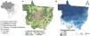
Material and methodsStudy areaWe conducted this study in Mato Grosso state, Brazil, which is home to a mosaic of vegetation from three biomes: the Amazon (53% of the state), Cerrado (40%), and Pantanal (7%) (IBGE, 2020). Approximately 38% of native vegetation in the state has already been converted to agricultural production (e.g., soybeans, cattle, and corn; Souza et al., 2020). In the last two decades, the cleared area increased from 221,000 km² to 322,000 km² (Souza et al., 2020), and the remaining native vegetation has become increasingly exposed to forest degradation driven by a combination of natural and anthropogenic disturbances such as fire (Brando et al., 2020a; Rossi and Santos, 2020). In recent years, extreme drought events have also become more frequent, increasing the flammability of the region and leading to large forest fires that may persist in the region even as deforestation slows (Brando et al., 2020a).
Land use and land cover classificationTo define the biome boundaries within Mato Grosso, we followed the delineations published by the Brazilian Institute of Geography and Statistics (IBGE). We first merged the Cerrado and Pantanal biomes into a single vegetation category (henceforth, Cerrado), given their similar vegetation, predominantly savanna and grassland (Kuschnig et al., 2021). We then classified the land use categories into Conservation Units (CUs) and Indigenous Lands (ILs) according to the Mato Grosso state Secretariat for the Environment (SEMA-MT). All areas outside CUs and ILs were considered multiple use areas (MUs; Fig. 1), which includes areas of native vegetation, as well as deforested and degraded areas. Following these criteria, the state of Mato Grosso currently has 113 Conservation Units (4.6% of the state; SEMA-MT, 2020) and 75 Indigenous Lands (15.2% of the state; SEMA-MT, 2020), representing 20% of the state's territory (Table S1).

The Brazilian protected area system groups CUs into two use categories: "Integral Protection" areas (Áreas de Proteção Integral), which afford strict protection that prohibits most uses, and "Sustainable Use" areas, which permit sustainable use and management under established rules (SNUC - Law 9.985/2000). Indigenous Lands, on the other hand, are designated to protect the environmental resources and land needed to guarantee the well-being, livelihoods, and cultures of Indigenous Peoples (Article 231 of the Brazilian Federal Constitution of 1988). Our analysis excluded one type of Sustainable Use CUs (Áreas de Proteção Ambiental) because this CU designation allows a wide array of land uses, including economic activities (e.g., agriculture and urban areas) that could bias the results when comparing CUs, ILs, and MUs (Françoso et al., 2015). To reduce possible spurious effects related to edge effects, we generated an internal buffer of 500 m in the CUs and ILs. Given the coarse resolution of some remote sensing data used to quantify environmental services (500 m), CUs and ILs smaller than 1500 ha were excluded. We considered this the minimum viable area for analyzing the energy balance components covered here. After filtering, 40 CUs (Amazônia: 18 and Cerrado: 22) and 68 ILs (Amazônia: 33 and Cerrado: 35) remained in our analysis (Table S2).
To separate the protected areas (CUs and ILs) into their respective biomes (Amazon and Cerrado), we used the biome polygons published by IBGE and the CU and IL boundaries published by the Mato Grosso State Environmental Secretariat (SEMA-MT). In cases where a CU or IL straddled two biomes, we followed the biome classification recommended by SEMA – MT. Finally, we extracted all CUs and ILs from the biome layers to remove their effects on multiple-use areas.
Energy balance components and ecosystem propertiesWe quantified three key energy balance variables – land surface temperature (LST), evapotranspiration (ET), and surface albedo (Table 1). We also quantified five predictors of changes in the energy balance variables: land use or land cover changes, normalized difference vegetation index (NDVI), precipitation (PPT), maximum climatological water deficit (MCWD), and burned area in CUs, ILs, and MUs (Table 1). These analyses spanned the period from January 2001 to December 2020, with the time series for each variable adjusted depending on data availability. For details on the temporal and spatial resolution of each variable, refer to Table 1.
Datasets used to quantify energy balance components and ecosystem properties. LST – land surface temperature; ET – evapotranspiration; NDVI – Normalized Difference Vegetation Index; PPT – Precipitation; MCWD – Maximum Climatological Water Deficit; CHIRPS – Climate Hazards Group InfraRed Precipitation with Station data.
| Variable | Product | Time series | References |
|---|---|---|---|
| LST (1 km; 8-day) | MOD11A2 | 2001 to 2020 | (Wan et al., 2004) |
| ET (1 km; 8-day) | MOD16A2 | 2003 to 2020 | (Mu et al., 2011) |
| Albedo | 2001 to 2016 | Schaaf et al., 2002; Silvério et al., 2015 | |
| Land use and land cover (30 m) | MapBiomas Project version 6.0 | 2001 to 2020 | Souza et al., 2020 |
| NDVI (250 m; monthly) | 2001 to 2020 | ||
| PPT (5 km, 1-day) | CHIRPS | 2001 to 2020 | Didan et al., 2015 |
| MCWD (5 km, monthly) | 2001 to 2017 | Aragão et al., 2007; Malhi et al., 2008 | |
| Burned area (500 m, monthly) | MCD64A1 | 2001 to 2020 |
Using the Google Earth Engine platform, we extracted annual values for each variable described above within the boundaries of each CU, IL, and MU. To evaluate differences between biomes (Amazon and Cerrado) and among land use types (CUs, ILs, and MUs), we performed non-parametric analyses of variance (Kruskal–Wallis) followed by a post-hoc multiple comparison test (Tukey's test). To assess the variation among the response variables (ET, LST, albedo) as a function of predictor variables (protection category, biome, PPT, MCWD, NDVI, land cover, and burned area), we used Linear Mixed-Effects Models (LME) considering the size of CUs and ILs as a random effect. Initially, we tested the correlation between the predictor variables (Table S3). We then used the corrected Akaike information criterion (AICc) to select the best model for each response variable.
We analyzed temporal variations, including the effect of droughts on each response variable (LST, ET, albedo, active fires, and burned areas) within CUs, ILs, and MUs. To do so, we performed linear regressions between the variables for the study period with the intensity of drought based on the MCWD.
All analyses were run in the R 4.4.2 environment (R, 2020). Using the cor function from the Stats package, we tested the correlation between predictor variables. To evaluate the effect of predictors on response variables, we used the lmer function (Bates et al., 2015) in the lme4 package. To select the best model, we applied the dredge function from the MuMin package, and for pairwise comparison we used the emmeans (Lenth, 2018) and MultcompView packages (Graves et al., 2023).
ResultsLand use and land cover changesThe area of native vegetation in Mato Grosso has declined by 10% over the last two decades, from 73% in 2000 to 63% in 2020 (Fig. 2). This change represents an area of 91 thousand km² of native vegetation that was converted to other uses, mainly pastures and farming. Of this converted area, 69% (63,000 km²) was in Amazonia and 31% (28,000 km²) in the Cerrado. Of the area deforested in the Cerrado portion of Mato Grosso state, 22,000 km² was savanna and 6,000 km² was forest vegetation (Fig. S6).

The conversion rates of native vegetation were higher in MUs than in protected areas (CUs and ILs) in the Amazon and Cerrado. Within the MUs, there was a 15% reduction in native vegetation (73% to 58%) in the Amazon and 9.5% in the Cerrado (65% to 55.5%). Within the CUs, there was no reduction in native vegetation in the Amazon (native vegetation cover remained at 93%) and only 1% in the Cerrado (from 90% to 89%). In ILs, there was a 1% reduction in native vegetation in the Amazon (97–96%) and 2% in the Cerrado (97–95%).
Active fires and burned areaIn the Amazon, our analysis detected three times fewer active fires per km² in protected areas (CUs and ILs) than in MUs, and CUs had fewer active fires than ILs. In the Cerrado, the number of active fires per km² was similar between MUs and ILs, but both had more active fires than CUs. Ther was a downward trend in the number of active fires detected in both biomes after 2010 – a pattern that was particularly pronounced in MUs in the Amazon (Fig. S4). On the other hand, we observed an increase in the number of active fires detected during extreme drought years (e.g., 2005 and 2007) for both Amazon MUs and Cerrado ILs, as well as a notable spike in active fires in Cerrado ILs in 2010 and 2020.
We observed a strong drought effect on the proportion of burned areas in both biomes (Fig. S6). In 2001, the total burned area in Mato Grosso was 31,000 km² (20,000 km² in the Cerrado and 11,000 km² in the Amazon), which increased to nearly 52,000 km² during the extreme drought of 2005 (31,000 km² in the Cerrado and 20,000 km² in the Amazon). Amazon native vegetation was more susceptible to burning during the 2005 drought, as the burned area was ∼66% higher than the historical average in MUs and twice the average area in ILs. On the other hand, within CUs (3%), we found no significant increase in burned area in 2005. For the same year, Cerrado MUs showed a 53% increase in burned area during May compared to the historical average.
In contrast, the burned area in Cerrado CUs and ILs was proportionally lower in 2005 than the historical average. Moreover, the area burned in 2003 was more than twice that of the historical average. Finally, from 2001 to 2020 the fire frequency was higher in the Cerrado (particularly in northeastern Mato Grosso) than in the Amazon (particularly in the north). We also observed a high fire frequency in most of the Cerrado ILs.
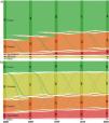
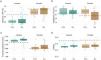
Changes in energy balance componentsWe observed significant differences between the biomes for ET, LST, and albedo. At the beginning of the study period, daytime LST was consistently higher and ET was lower in the Cerrado compared with the Amazon for all three land cover categories (Fig. 3). There was a smaller difference between biomes for nighttime LST and albedo for the three land-cover categories (Fig. 3).

Land surface temperature (LST), evapotranspiration (ET), and albedo for the first and last years of the study period (2001–2020). The shade and pattern of each box indicate significant differences (p < 0.05) between each category, based on an analysis of variance (Kruskal–Wallis) followed by the post-hoc multiple comparison test (Tukey's test). The thickness of the arrow is proportional to the observed change over time.
At the beginning of the study period (2001), multiple-use areas in the Amazon portion of Mato Grosso had higher LST (+1.0 °C) and albedo (+6%), lower ET (∼110−170 mm) and similar nighttime LST compared with CUs and ILs (Fig. 5). MUs from the Cerrado portion also had higher mean daytime LST (0.8–1.5 °C) and albedo (7–10%), lower ET (30−120 mm), and similar nighttime LST compared to CUs and ILs (Fig. 3). There was a small difference between CUs and ILs at the beginning of the study period for both the Amazon and Cerrado regions. We observed more significant differences in ET, with ILs showing higher values (80−90 mm) than CUs in both biomes (Fig. 3).
Are external pressures changing the ability of CUs and ILs to reliably regulate the energy balance?We observed a pronounced increase in daytime (>1.4 °C) and nighttime (>0.6 °C) LST and albedo (>6%) over the last two decades for MUs located in the Amazon (Figs. 3–4 and S1–S4). We also observed a slight change in CUs and ILs, with an increase in daytime (>0.2−0.3 °C) and nighttime (>0.5−0.7 °C) LST, ET (∼20 mm), and albedo (>0.4–1.2%; Fig. 3). During the same period for the Cerrado, the MUs showed similar increases in LST (daytime: >1 °C; nighttime: >0.4 °C) compared to CUs (daytime: >1.2 °C; nighttime: >0.3 °C) and ILs (daytime: >0.9 °C; nighttime: >0.6 °C). However, only MUs showed an increase in albedo (>3%), whereas CUs and ILs showed a moderate reduction (Fig. 3). We also observed an increase in annual evaporation for the entire Cerrado portion of MT (∼120 mm).

We observed a slight increase in the annual average ET (>2%) for all land-use types in the Amazon (Fig. 3). Comparing the dry and rainy seasons over two consecutive periods (2003–2010 and 2011–2020), we observed a 20 mm yr−¹ (−1.5%) reduction in ET during the rainy season and an 88 mm y−¹ (7%) increase in ET during the dry period. We also observed the largest differences between CUs, ILs, and MUs during the dry period, especially in the Amazon portion of MT (Fig. S5).
What are the main predictors of changes in LST, ET, and albedo?The model with the best fit to explain variations in diurnal LST included protected area category (CUs and ILs), biome, total area burned annually, native vegetation (%), NDVI, MCWD, PPT, and the interaction between biomes and percentage of native vegetation (Table S4). Together, these variables explained 66% of the variability in daytime LST (r² conditional = 0.98, r² marginal = 0.66). Burned area had the greatest positive effect (Fig. S5), whereas native vegetation had the greatest negative effect on daytime LST (Table S5). The predictive model pointed to native vegetation loss as the main factor affecting daytime LST in UCs and ILs. For example, in 2020, protected areas had an average of only 2% deforestation within their borders. Our results indicate that a 20% increase of in the deforested area could increase LST by up to 2 °C in Amazon protected areas and 1 °C in the Cerrado (Fig. 5).

For nighttime LST, the best model included the protected area category, biome, burned area, native vegetation, NDVI, MCWD, PPT, and the interaction between biome and the percentage of native vegetation (Table S4). However, these predictors explained only 20% of nighttime LST variability (r² conditional = 0.98; r² marginal = 0.20). MCWD had the greatest positive influence on nighttime LST, whereas NDVI had the greatest negative influence (Table S5).
The best-fit model to explain the variability in ET included the protected area category, biome, burned area, MCWD, NDVI, PPT, and native vegetation, as well as interactions between biome and burned area and between biome and native vegetation (Table S4). The model explained 74% of the variation in ET (r² conditional = 0.92; r² marginal = 0.74), with NDVI showing the greatest positive effect on ET and MCWD showing the greatest negative effect (Table S5). The best-fit model to explain variations in albedo included only the proportion of land use, which had a negative effect on albedo (i.e., the higher the proportion of native vegetation, the lower the albedo; Table S4). The final model with this variable explained 19% of the albedo variation (r² conditional = 0.88; r² marginal = 0.19; Table S5).
DiscussionOur investigation revealed the crucial contribution of protected areas to mitigating the consequences of global warming over a substantial geographic area at the transition between the Cerrado and Amazon biomes. Protected areas (CUs and ILs) help to maintain low temperatures, low albedo, and high evapotranspiration. Our results show that protected areas help cool regional land surface temperatures, even during extreme droughts. This confirms results reported by Caioni et al. (2020) and is consistent with recent studies showing that, by conserving native vegetation, protected areas also protect key ecosystem services such as carbon stocks throughout the Amazon (Walker et al., 2020; Kruid et al., 2021).
This study revealed a noteworthy 6% (equivalent to 66 mm yr−1) higher atmospheric water contribution by CUs and ILs compared with MUs. Our models attribute reductions in ET to factors including native vegetation loss, heightened forest degradation due to fires, and increased water stress. Furthermore, our observations during the dry season indicated an increase in evaporative demand, likely induced by feedback from global climate changes, as previously reported by Jung et al. (2010) and Oliveira et al. (2014). These findings align with prior research highlighting the adverse impact of climate and land use changes on ET (Silvério et al., 2015), leading to a shorter rainy season (Leite-Filho et al., 2019) and heightened climate risks to agriculture (Rattis et al., 2021).
Our study showed that MUs in the Amazon and Cerrado reflect more shortwave radiation than protected areas, storing less energy to drive the hydrological cycle. Contrary to our expectations, we observed increased albedo in Amazon protected areas. The conversion of areas outside protected areas in this region has continuously increased with the growth of mechanized production of export commodities, which could compromise the capacity of protected areas to regulate regional climate in the future. A possible explanation for this increased albedo in forested regions is that these areas already have a relatively low albedo, which may increase with periodic disturbance, particularly in years with high water stress (Caioni et al., 2020).
The delicate balance between ecosystem services and water resources in the Amazon faces increasing threats from forest degradation and changing environmental conditions, which require continued conservation efforts and climate mitigation strategies (Silva et al., 2020, Lapola et al., 2023; Matricardi et al., 2020). Although protected areas have been more stable over time than multiple-use areas, they have also suffered from disturbances due to environmental degradation (e.g., fires) and extreme weather events. Our findings confirm those of previous studies showing that intact forests are increasingly vulnerable to degradation and disturbance, which may originate outside protected areas but have effects within their boundaries (Kruid et al., 2021; Maracahipes-Santos et al., 2020; Walker et al., 2020). This includes observed increases in surface temperature and albedo (Silvério et al., 2015; Rodrigues et al. 2022).
We found interesting differences between CUs and ILs in both biomes and noted a greater probability of fires during drought years in Amazon ILs and MUs than in the Cerrado. Indigenous Lands had higher albedo and LST than CUs, possibly due to differences in management since ILs have the dual purpose of promoting ecosystem integrity and safeguarding the land rights and cultures of Indigenous peoples (Welch and Coimbra Jr., 2019). The increased probability of fires during drought years in Amazon ILs and MUs may be explained by the fact that Amazon forests have greater canopy cover and moisture, which are efficient barriers against fires in normal years. In contrast, during drought years, the forest loses more moisture, dropping leaves and branches that provide a large amount of dry, combustible material (fuel) and favor the spread of fires (Brando et al., 2020b).
Since rainforest species are inherently less drought-tolerant, they take longer to recover than more xeric Cerrado species that are frequently exposed to drought and adapted to seasonal water stress (Xu et al., 2022). Our study showed that intense droughts increased the burned area in CUs and ILs in both the Amazon and Cerrado. However, MUs did not significantly increase burned areas during extreme droughts. These results are striking in light of previous studies, which suggest that the frequency and intensity of droughts in the Amazon will increase in the future (Brando et al., 2020a; Duffy et al., 2015). In this novel climate, protected areas will be essential for safeguarding the Amazon’s ecosystem services and reducing the negative impacts of climate change in the region.
It is important to recognize the role of global climate change, associated with increasing atmospheric GHG concentrations (IPCC 2022), as a driver of changes in local climate observed over the study period. Global warming of ∼1.1 °C has exacerbated local environmental stressors such as deforestation, water stress, and forest fires (Ribeiro et al., 2022), amplifying their impacts on ecosystem functioning. For example, the heightened flammability of forests in Indigenous Lands (ILs) and Conservation Units (CUs) can be attributed to warmer global temperatures and associated increases in the frequency of intense drought events (Brando et al., 2020b). These factors contribute to increased fire activity in the landscape and may alter energy balance variables (Dutra et al., 2023), intensifying the local and regional impacts attributed to land cover change (Silvério et al., 2015). Interactions among these synergistic stressors could push ecosystems towards permanently degraded states (Flores et al., 2024).
Mato Grosso is Brazil’s leading producer of soybeans and meat, yet both have grown at the expense of the region’s native Cerrado and Amazon vegetation (dos Reis et al., 2020). Our results show that the continued loss of native vegetation could put the regional energy and water balance at risk and compromise ecological and economic functioning. Increasing agricultural production without further deforestation would require developing technologies for sustainable intensification and recovery of deforested and underused lands. Potential pathways include existing mechanisms such as the soy moratorium, environmental monitoring, and enforcement of environmental laws (e.g., Brazil’s Native Vegetation Protection Law), coupled with development of economic incentives such as payments for environmental services.
The rapid growth in market demand for sustainable products is promising, as consumers who demand sustainability are also willing to pay a premium for these products. However, these incentives must be coupled with engagement of local communities, including the 80 thousand small producers occupying 6 Mha of official settlements in Mato Grosso. Workshops with such local actors could help align sustainable production practices with consumers interested in this market, while increasing income for family farmers and reducing deforestation pressures by this group. Several studies have recommended reducing deforestation and increasing agricultural production (Kruid et al., 2021; Stabile et al., 2020), but implementing these strategies will require using scientific understanding to raise awareness among lawmakers, producers, and consumers in the general population.
ConclusionsOur study confirms that Conservation Units and Indigenous Lands contribute more to climate regulation than multiple-use areas, emphasizing the crucial role of protected areas in providing regional water supply services and mitigating ongoing climate change. The Conservation Units and Indigenous Lands of Mato Grosso are key to sustaining agriculture, carbon stocks, biodiversity, and other ecosystem services. Nonetheless, persistent degradation pressures from forest fires, deforestation, and global climate change now threaten the capacity of protected areas to maintain lower land surface temperatures and albedo and higher rates of evapotranspiration. Our results demonstrate the increasing vulnerability of protected areas to external pressures, underscoring the urgent need for enhanced conservation measures to mitigate the effects of ongoing environmental changes. Our analysis identified key predictors such as burned area, native vegetation, and climate variables, providing valuable insights into the processes threatening protected areas today. Such information is crucial for raising awareness of the effects of deforestation and forest degradation on climate and developing effective management strategies to preserve these resources for future generations.
Conflict of interestThe authors declare that they have no known competing financial interests or personal relationships that could have appeared to influence the work reported in this paper.
We thank all members of the research team at the Instituto de Pesquisa Ambiental da Amazônia (IPAM), and the Graduate Program of Ecology and Conservation at the Universidade do Estado do Mato Grosso (UNEMAT). This study was partially funded by CAPES(Coordenação de Aperfeiçoamento de Pessoal de Nível Superior, Brazilian Ministry of Education) through scholarships to HKA (88887.195226/2018-00 and 88881.624476/2021-01) by the Brazilian National Council for Scientific and Technological Development (CNPq), through a productivity grant DVS (311468/2022-5), and grants from NASA (#22-LCLUC22_2-0007), theMott Foundation (#2021-08938), and the Gordon and Betty Moore Foundation (#9957). Thanks also to Paulo Brando for his support, constructive comments, and suggestions.
The following is Supplementary data to this article: